Commercial tree felling and the occasional storm contributes emphasises that Kielder is a changing landscape with new views and vistas being revealed on a regular basis. So, in addition to the better-known views listed below, you may well discover your own special place in which to picture yourself.
If you are keen to explore, please don’t get carried away and be too ambitious. Kielder is vast. The distance around Kielder Water is 26 miles and Kielder Forest is made up of over 150 million trees across 250 square miles.
As well as being a place for enjoyment, Kielder is a place where people live and work. From time to time some trails and areas may be closed for reasons such as tree felling and site restoration. It is always advisable to check at one of our visitor centres for updates.
It is always advisable to check the weather forecast before you set off as conditions can change rapidly, and during extreme weather trails may not be passable.
For your own safety and enjoyment, please observe signs and barriers and respect local communities by staying on trails and parking in designated visitor car parks.
Following these simple rules will ensure a safe and pleasant experience for all.
What 3 Words: healers.amending.bells
Adjacent to the Kielder Column artwork and Bakethin Weir on the south shore, is a view to the north and west across Bakethin Reservoir and Bakethin Nature Reserve and to the south and east over the enormity of Kielder Water.
The mini-dam or weir is 165 metres in length and keeps the water at a constant level in Bakethin Reservoir, preventing unsightly mud flats forming in the upper reaches when water levels are low. This has created Bakethin Nature Reserve to the north, a Northumberland Wildlife Trust conservation area for local plants, birds and other wildlife including otters.
What 3 Words: newlyweds.older.shutting
A short distance from Kielder Belvedere on the north shore Lakeside Way, in an isolated stand of Scot's pine is the 55/02 artwork with a great view across to the south shore of Kielder Water.
What 3 Words: coverings.building.tenses
Near Tower Knowe Visitor Centre, and accessed from the C200 or a short detour from the Lakeside Way, Elf Kirk viewpoint gives a sweeping, breathtaking view from Kielder Dam to Bull Crag peninsula and Whickhope Inlet and across to the north shore of Kielder Water.
What 3 Words: florists.decimals.slogged
Away from the shoreline of Kielder Water, 12 miles north east of Kielder Castle on the Forest Drive toll road (suitable for 4x4 vehicles only) can be found an idyllic waterfall in a beautiful tree lined gorge. The Hindhope Linn walk starts from the Blakehopeburnhaugh picnic site.
What 3 Words: outdoor.reworked.pencils
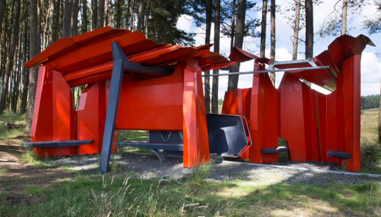
Sited at Benny Shank, just off the Lakeside Way on the north shore of Kielder Water, this award winning and visually striking shelter is part of the Kielder art and architecture programme is open to visitors at all times of the year and gives a different view Kielder Water looking southwards to Bull Crag peninsula, Tower Knowe and Kielder Dam.
Kielder Observatory: - What 3 Words: jetliner.unloads.logo - and - Kielder Skyspace: - What 3 Words: wades.mailers.improving
On fell above Kielder village, both Kielder Skyspace artwork experience and the near neighbour Kielder Observatory offer stunning elevated views over Bakethin Nature Reserve and Kielder Water.
What 3 Words: spoiler.wharfs.overheat
A short stroll from Kielder Village along the track bed brings you onto Kielder Viaduct, part of the former Border Counties Railway. This gives a view of the North Tyne River as it enters the upper reaches of the Kielder Water system at Bakethin Reservoir and is a great wildlife spotting location. The viaduct is one of the best-preserved examples of a 'skew-arch' bridge in the UK. Find out more in the History & Heritage section.
What 3 Words: rejects.montage.trickster
For most visitors to Kielder, this is their first view of Kielder Water within its forested landscape and a truly “Wow” moment. If you are driving, be prepared for this to suddenly come into view. To stop and take it all in, turn right, signed for Hawkhope the park at the corner of the dam.
What 3 Words: mute.prowling.nozzles
The Lakeside Way on north side of Bull Crag peninsula, including Freya’s Cabin artwork and the section of the former valley road, is a constant vista with many places to stop and admire the view.
What 3 Words: wake.emotional.bypassed
Part of a pleasant, wooded valley section of the Lakeside Way on Lewisburn inlet on the south shore which takes in the unique Lewisburn suspension bridge and this inlet overlook view which was the favourite dwell point of Dave Patterson, one of the engineering team who built the Lakeside Way.
What 3 Words: thrillers.saves.scornful
A site of local industrial significance as well as a fabulous viewpoint, Plashetts incline, a straight tree lined avenue stretches from the North Haul road, and disappears into Kielder Water. In the past this was an inclined railway which took coal from Plashetts Colliery via the wagonway which is now North Haul Road, down the fell to Plashetts Station on the Border Counties rail line.
The site of Plashetts Station is now beneath the water but the course of the rail line can be seen as it emerges on the north side of Bakethin Reservoir before crossing Kielder Viaduct and skirting Kielder Village and onwards into Scotland to Riccarton Junction where the Border Counties met the Waverley Line.
What 3 Words: twice.unicorns.sporting
Offering great views of Kielder Water and Kielder Dam, you can also experience Wave Chamber at this location, another feature of the Kielder Art & Architecture programme. Within its dark interior, the walls echo the wave sounds.
An image of the water is projected onto the chamber floor and the floor appears to become liquid. The image is clearer on late afternoons and sunny days. Wave chamber is on the Belling peninsula and a short distance from the Lakeside Way on the north shore.


